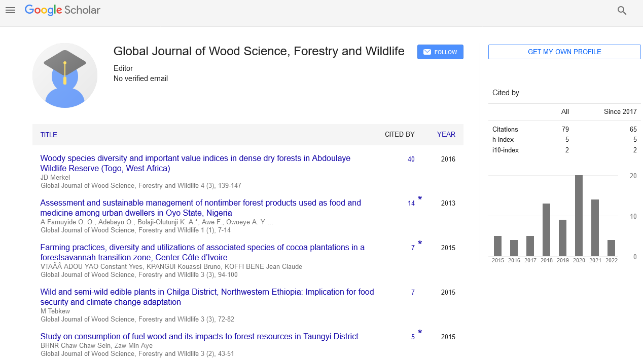

Received: 20-Jul-2022, Manuscript No. GJWSFW-22-74066; Editor assigned: 25-Jul-2022, Pre QC No. GJWSFW-22-74066 (PQ); Reviewed: 08-Aug-2022, QC No. GJWSFW-22-74066; Revised: 16-Aug-2022, Manuscript No. GJWSFW-22-74066 (R); Published: 23-Aug-2022, DOI: 10.15651/2449-1780.22.11.008
Forestry is a significant rural industry and a priceless natural resource in India. India is one of the top ten nations in the world for forest coverage. India shares 67 percent of the world's total forest area with nine other countries. India's forest cover rose at a rate of 0.7% per year between 2000 and 2010, following a period in which there were significant concerns about forest degradation. The Food and Agriculture Organization of the United Nations estimates India's forest cover to be over 68 million hectares, or 22% of the nation's land, as of 2010. The country's forest cover increased to 69.8 million hectares by 2012, an increase of 5,871 square kilometers in just two years, according to satellite data from the 2013 Forest Survey of India. Unless India makes large, prompt, and consistent efforts to increase electricity generation and power plants, the poor in India's rural and urban areas will continue to rely on irresponsible deforestation and fuel wood use to meet their energy needs.
India's reliance on fuel-wood and forestry products as a primary energy source is a significant cause of the nation's practically constant haze and air pollution, and is unsustainable for the ecosystem. The Valley of Flowers in Uttarakhand has methods for measuring the amount of forest cover. Before the 1980s, India employed a bureaucratic method to gauge the extent of its forests. Even though there was no vegetation present when a piece of land was designated as being covered by the Indian Forest Act, officials still deemed it to be a documented forest. The entire extent of reported forest utilizing this "forest-in-name-only" methodology was 71.8 million hectares, according to official Indian data. Due to the fact that this is only a question of bureaucratic record keeping and has no influence on reality or functioning as a useful benchmark, any comparison of India's pre-1987 forest coverage numbers to the country's current forest coverage is worthless.
The first space satellites for genuine forest cover remote sensing were utilized in the 1980s. The following criteria were used to categories the forests of India: All land with a tree canopy density of more than 10% and an area larger than one hectare is considered to have forest cover. Any area that has trees covering at least 70% of its surface is considered to be a forest. Due to the fact that this is only a question of bureaucratic record keeping and has no influence on reality or functioning as a useful benchmark, any comparison of India's pre-1987 forest coverage numbers to the country's current forest coverage is worthless. The first space satellites for genuine forest cover remote sensing were utilized in the 1980s.
The forests of India were categorized using the following standards are Forest cover is defined as the presence of trees above 10% of the land surface in an area bigger than one hectare. A forest is defined as any area with trees covering at least 70% of its surface. In intertidal and/or coastal areas, mangrove forests are salt-tolerant forest ecosystems. Moderate Density Mangrove canopy with a public forest canopy density of between 10% and 40% on all lands in tropical and subtropical climates. Forest all regions with a forest cover and canopy density of 40 to 70%.
The area that is covered in mangrove vegetation is known as mangrove cover, and it may be digitally computed using remote sensing data. It falls under the category of forest cover and is divided into three categories: open, moderately dense, and highly dense. Areas devoid of any forest cover are referred to as non-forest land. Generally found in and surrounding forest zones, scrub is described as all places with shrubs and/or weak tree development, notably small or stunted trees with a canopy density of less than 10%.
Tree farm cover Outside of the reported forest area, unfrosted land with a minimum practicable area of 1 hectare but no forest cover is included.
Trees can grow outside of defined forest zones as well as inside of forests.